You are using an out of date browser. It may not display this or other websites correctly.
You should upgrade or use an alternative browser.
You should upgrade or use an alternative browser.
What I saw during my walk today
- Thread starter Trusylver
- Start date
Fellow students, learning to lead oudoor expeditions, happy to report that i did not fall in with the sharksGorgeous. I can´t remember though: did you have an actual group to care for or was this with fellow students?
alligatorob
Respected Member
I like your pumpkin patch Flyer, not so many weeds! Tru that looks like a beautiful place, I love the water and have done a lot of canoeing, so I can really appreciate it.
Did another very slow walk close to home, went the other way, LaMa, I tried to get another horror show shot, this is the best I could do. The red roof is mine.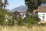
Did another very slow walk close to home, went the other way, LaMa, I tried to get another horror show shot, this is the best I could do. The red roof is mine.

alligatorob
Respected Member
Another meander today, I am going a bit farther, but still taking it slow and easy. Just kind of circling my house.
Got a few more pictures.
Look for:

And another possible horror film location for LaMa.

Got a few more pictures.
Look for:
- My house, in the circle.
- The peak I "scaled" earlier in the summer, red arrow to the right.
- An "I" whitewashed on the mountain side. It is for the Intermountain Indian School which was located just below. It was a boarding high school for native Americans, mostly Navajo, who were brought here from the reservation. The reservation is hundreds of miles to the south, the poor kids went the whole school year without seeing parents or family. Its an idea that has been mostly discredited, and the school has been closed for a long time now, some of the buildings still exist but are used for other things. I am surprised anyone has the interest to maintain the old I. Many high schools and other schools have similar letters on the mountains above, its a common local practice.
- And if you look you will see horizontal lines on the mountain (no arrows), two very clearly visible, the highest at an elevation just below the I. These are old Lake Bonneville beaches. The highest was the maximum depth, or height, the lake reached about 15,000 years ago, it then broke through and discharged to the Snake and Columbia rivers and eventually to the Pacific. The lake stabilized at the second lower level for a few thousand years, then it got dry and the lake evaporated down to a remnant, the Great Salt Lake we have today. The old Lake Bonneville covered most of Northern Utah as well as parts of Idaho and Nevada, it was much larger than any lake we have in North America now.

And another possible horror film location for LaMa.

alligatorob
Respected Member
Thanks LaMa, actually that building is not completely abandoned, farmer still uses it for storage, but not often. I like the creative use of old tires to hold the metal roof down, so much easier than nails...
Another slow and easy walk today, went out to the bird refuge to do it. Nice walk, but not many birds today.
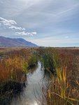
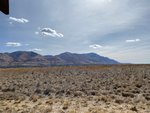
Another slow and easy walk today, went out to the bird refuge to do it. Nice walk, but not many birds today.


alligatorob
Respected Member
Did another from home meander today, walked 5 km. At the far end I found a small wildlife park I did not know about. Did not walk around in it, I did not want to walk much more, but I will go back.
A view along the way

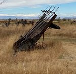
More abandoned farm machinery
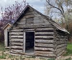
And another old house, for LaMa, actually this is probably an old settler's cabin but I did not see a sign on it.
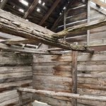
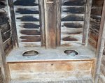
And it came with a 2 seater
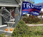
The message in the window behind the flag says "Help Me", kind of wonder what kind of help they are looking for...
A view along the way

More abandoned farm machinery

And another old house, for LaMa, actually this is probably an old settler's cabin but I did not see a sign on it.


And it came with a 2 seater

The message in the window behind the flag says "Help Me", kind of wonder what kind of help they are looking for...

Maybe the Trump voter doesn't live alone. A ghastly thought! I love the cabin and hill pictures.The message in the window behind the flag says "Help Me", kind of wonder what kind of help they are looking for...
alligatorob
Respected Member
That's what I was thinking too LaMa. I voted today, maybe that will help a little.
Very short walk today, I drove to the nature park I discovered yesterday and walked every possible path, dead ends and all, still it was less than 2 km. I was not so energetic as yesterday so I called it good enough. Before the surgery I would have just powered though the tired feeling and kept going, but now I am taking it easier. Tomorrow will be two weeks, another two or so and I should be back closer to normal. End of the trail:

Some interesting chainsaw art along the way, artist unknown
Very short walk today, I drove to the nature park I discovered yesterday and walked every possible path, dead ends and all, still it was less than 2 km. I was not so energetic as yesterday so I called it good enough. Before the surgery I would have just powered though the tired feeling and kept going, but now I am taking it easier. Tomorrow will be two weeks, another two or so and I should be back closer to normal. End of the trail:

Some interesting chainsaw art along the way, artist unknown

alligatorob
Respected Member
Did a 4.6 km meander today. In keeping with my effort to go somewhere different I walked from home along the highway into town, or the beginning of it. Got a few pictures, but not so scenic.
Along the way.

Made it to the gym, where I turned around. Kind of surprised how easy it is to walk to the gym, makes me wonder why I don't always walk there.

Along the way.
Made it to the gym, where I turned around. Kind of surprised how easy it is to walk to the gym, makes me wonder why I don't always walk there.

overlandflyer
Well-known member
alligatorob
Respected Member
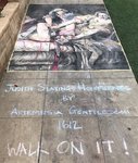
So did you walk on it?
overlandflyer
Well-known member
yes i did carefully walk over the art ... as instructed...
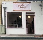
re: Phatties... funny... my first thought was that it referred to the clientele.
i suppose i could nitpick the sign maker for not suggesting Phattie's ... or Phatti's?
re: Phatties... funny... my first thought was that it referred to the clientele.
i suppose i could nitpick the sign maker for not suggesting Phattie's ... or Phatti's?
overlandflyer
Well-known member
alligatorob
Respected Member
Great pictures Err, must have been a great hike!
Can you say where you were?
Can you say where you were?

